


Lot n° 157 | Auction 543
Estimate € 12,000 - 18,000
Auction: 25 January 2022 at 15:00
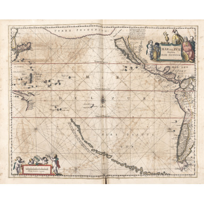
[BLAEU] - JANSSONIUS, Johannes (1588-1664) - Atlantis majoris quinta pars, Orbem maritimum [Novus Atlas, volume V: carte marittime]. Amsterdam: Janssonius, 1650. First edition of this famous work by Janssonius also known as the "Waterwereld". It is the first "maritime atlas (in the true sense of the word) printed in the Netherlands" (Koeman) and published as the fifth volume of the Atlas Novus. The maritime part consists of 23 maps of which 21 are published here for the first time. Koeman Me 164. Among the maps of the Americas "Mar de Zur, Hispanis, Mare Pacificum" is the first [graphic] of the whole Pacific Ocean (Burden). Folio (497 x 330mm). Engraved title, complete with 33 maps and double-page nautical charts, text and maps on guards; due to a pagination error, the pages [as in Koeman] go from pp. 166 to 191 and from 166 to 177 in the second part (at the bottom edge of the titles there is cut-out paper label with printed on the verso: "Multum legendum sed non fine. Plin. Jun. Lib. 6", browning, text leavess E2 and G2 shorter at the outer margin, first plate with tear in the center, some other plates with minor tears in the center, a few small marginal wormholes). Contemporary Dutch vellum decorated in gilt on covers, spine and edges (text block detached from binding, few stains, small holes, bottom of spine chipped and general light wear). Provenance: shelf label on front endpaper.
Estimate € 12,000 - 18,000